When and where is Storm Floris expected to hit Sweden?
Storm Floris Impact on Sweden
Storm Floris is projected to hit Sweden's west coast around 11 pm on Monday, traversing the country overnight and reaching the east coast by 5 am. The Swedish Meteorological and Hydrological Institute (SMHI) has issued yellow warnings for the Skagerrak and Kattegat seas but not for the Öresund Strait.
Affected Areas
The west coast, particularly the region between Halmstad and the Norwegian border, is expected to experience the most severe impact. Specific details on expected conditions for various cities include:
- Gothenburg: Heavy rain and wind gusts up to 14 m/s at 11 pm Monday, with winds increasing to 20 m/s by Tuesday evening.
- Halmstad: Storm arrival around 2 am Tuesday, with 12 m/s winds and 19 m/s gusts, accompanied by heavy rain.
- Malmö: Rain beginning around 9 pm Monday, intensifying around 3 am Tuesday with 9 m/s winds and 17 m/s gusts.
- Lund: Rain starting around 11 pm Monday, peaking around 2 am Tuesday with 8 m/s winds and 14 m/s gusts.
The storm initially impacted western Norway and Denmark before moving towards Sweden.
Storm Floris is expected to hit Sweden's west coast from about 11pm on Monday, cross the country overnight and arrive on the east coast at about 5am. Where is going to be worst affected?
Sweden's public weather forecaster SMHI has issued yellow warnings for the Skagerrak and Kattegat seas, but not the Öresund Strait between Denmark and Skåne, with the worst affected area expected to be the west coast between Halmstad and the Norwegian border.
At 6pm, the storm was still crossing Denmark and Western Norway with the heaviest weather crossing the Skagerrak on the wat to the coast north of Gothenburg.
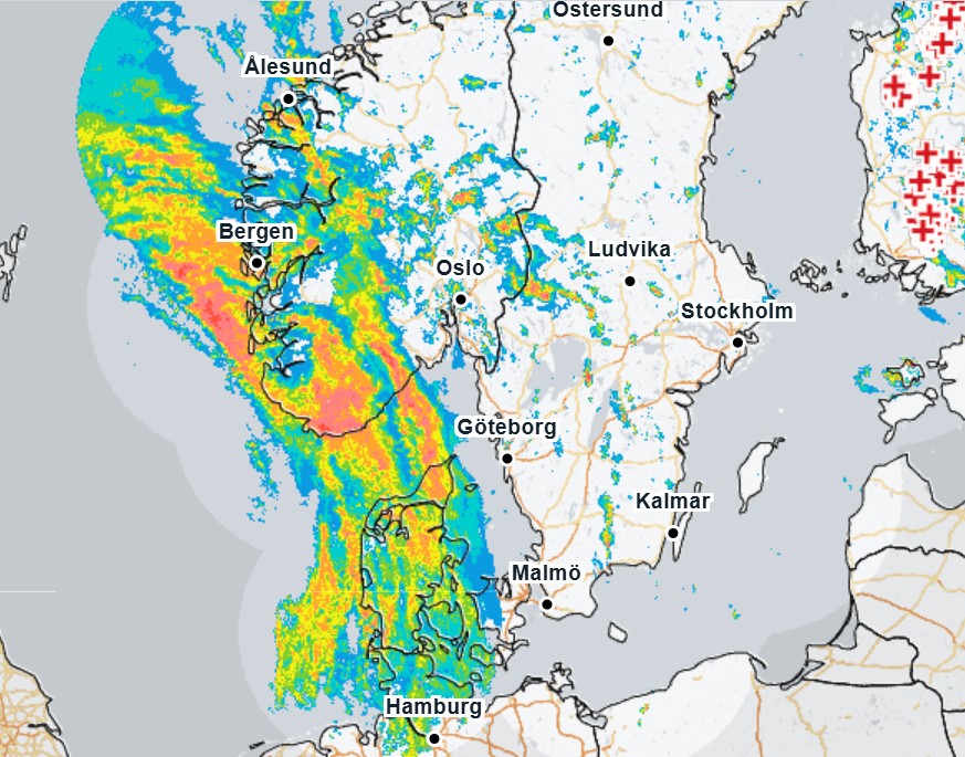
Storm Floris hit the west coast of Norway and Denmark on Monday evening. Photo: SMHI
Source: SMHI
Gothenburg
At 11pm, Gothenburg is forecast to be hit by heavy rain combined with winds that will include gusts of up to 14 m/s. The rains will stop at about 4pm, but the high winds will continue all day with gusts reaching as high as 20 m/s by about 7pm on Tuesday, with winds then slowly decreasing over Wednesday.
Halmstad
The storm will hit Halmstad, in the centre of the west coast, at about 2am, with winds of 12 m/s and gusts of 19 m/s, combined with heavy rain. The rain will stop at about 5am, but high winds will continue throughout Tuesday.
Advertisement
Malmö
It's expected to rain in Malmö from about 9pm on Monday with the rain getting heaviest at about 3am, when the wind will reach 9 m/s with gusts of 17 m/s.
Lund
Rain will start in Lund at about 11pm on Monday, reaching its heaviest at about 2am on Tuesday, when wind speeds will reach about 8 m/s, with gusts of 14 m/s. Rain will stop by 6am on Tuesday.
Was this article displayed correctly? Not happy with what you see?
If you often open multiple tabs and struggle to keep track of them, Tabs Reminder is the solution you need. Tabs Reminder lets you set reminders for tabs so you can close them and get notified about them later. Never lose track of important tabs again with Tabs Reminder!
Try our Chrome extension today!
Share this article with your
friends and colleagues.
Earn points from views and
referrals who sign up.
Learn more
Save articles to reading lists
and access them on any device